
As I talked about Yamanote Line before, it is a very convenient line circling central Tokyo.
It is a loop line circling major areas of centrall Tokyo. Here is a Yamanote Line map with station number.
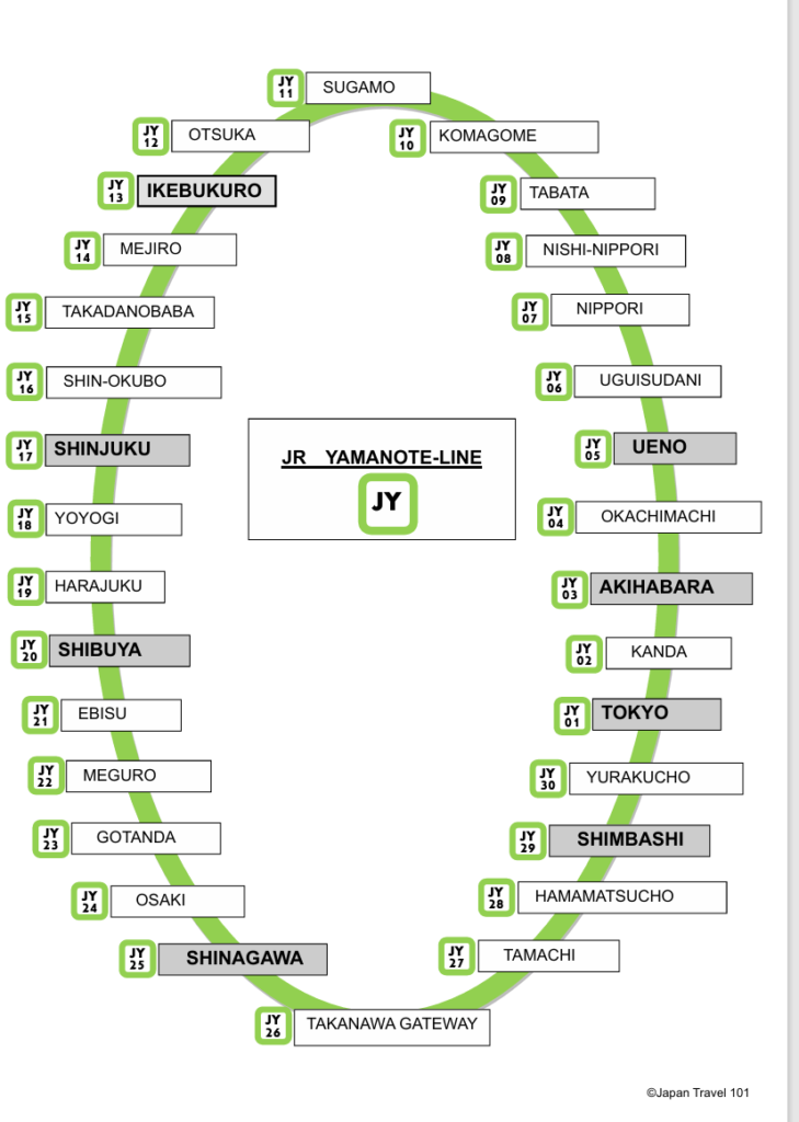
Things to know about Yamanote Line
- It’s a loop line with 30 stations.
- Symbol color is lime green
- JY stands for JR Yamanote Line and each station has station number.
- On average, each stations are 2 minutes apart. To go full loop, it takes 1 hour.
- It goes clockwise and counter-clockwise.
- To take Yamanote Line, follow the symbol color. Before you go on to the platform, make sure which direction you are going. On the map, stations with shades and bold letter are major stations. If you look at the sign, it will say Yamanote line for (major station name)
- For example, if you are at Tokyo station and want to go to Shibuya Station, go to “Yamanote Line for Shinagawa and Shibuya“
- Another way to tell direction is to look for the station number. If you are at Shinjuku Station (JY 17) and want to go to Shibuya Station (JY 20) go to the platform with higher number.
- Important Transfer Stations
- (JY 01) Tokyo for Shinkansen (bullet train) and Narita Express
- (JY 05) Ueno for Keisei Skyliner (also stops at (JY 07) Nippori Station) to go to Narita Airport
- (JY 25) Shinagawa to take Keikyu line to go to Haneda Airport
- (JY 28) Hamamatsucho to take monorail to Haneda Airport
- Some of the station names may not sound familiar
- (JY 30) Yurakucho is close to Ginza area
- (JY 19) Harajuku is also walking distance to Meiji Shrine and Omote Sando
If you know Yamanote Line, you will be able to go to major areas.

Comments